 English (UK)
  Македонски
KRIVA PALANKA, North Macedonia — As of December 2025, advanced monitoring equipment installed along the Kriva Reka river is fully operational and successfully collecting real-time hydrological data, marking a major step forward for the URBANFLOODS project in the Adriatic-Ionian region.
The newly installed pilot equipment features a specialized radar sensor capable of measuring both water level and flow velocity. According to the status report presented by the Center for Knowledge Management (CKM), the equipment is fully installed, operational, and supported by a solar power supply and data logging units.
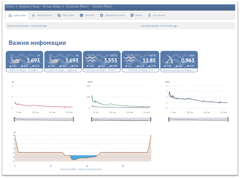
Recent dashboard data captures from late December 2025 through mid-January 2026 confirm that the system is actively transmitting critical metrics, including discharge rates (cubic meters per second), water levels (meters), and average surface velocity (meters per second). The system utilizes a "SmartObserver" platform to visualize these distinct parameters in real-time. This technical achievement is the result of a coordinated effort between local partners. The Faculty of Computer Science and Engineering at Ss. Cyril and Methodius University (FCSE-UKIM) is responsible for developing the hydraulic modeling that utilizes this data, while the Center for Knowledge management focuses on identifying critical infrastructure risks and mapping receptors at risk within the municipality.
"The hydraulic model for Kriva Reka is prepared by the UKIM FINKI and CKM is contributing to the process of risk evaluation by developing critical maps that are crucial for the community," states Branko Djurovic from the Center for Knowledge Management.
The Kriva Reka riverbed has been designated as the specific "Pilot Site" for testing these flood-management measures, while the broader Kriva Palanka watershed serves as the "Pilot Area". The data collected is vital for protecting the municipality's identified critical infrastructure, which includes two primary schools, a secondary school, a kindergarten, and a student home, all located in areas potentially susceptible to flood events.
Furthermore, the analysis of this real-time data aims to safeguard essential services. The pilot area includes key transport routes and water infrastructure, where flood events could lead to water contamination or the isolation of settlements due to damaged roads and bridges.
Currently operated by CKM, the equipment gathers data using remote configuration methods with recording frequencies as high as every 10 minutes. Following the installation and testing phase, ownership of the equipment is planned to be transferred to national stakeholders to ensure continued monitoring. This successful deployment allows local authorities and experts to move beyond historical analysis and utilize live data to develop adequate Flood Action Plans, providing the community with necessary mitigation measures against future hazards.
The URBANFLOODS project is supported by the Interreg IPA-Adrion Programme and is co-funded by the European Union.